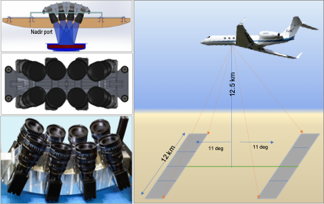
The Quantifying Uncertainty and Kinematics of Earth System Imager (QUAKES-I) is an airborne optical stereo-imaging system. The system is an eight-camera array mounted on a Gulfstream V aircraft and enables rapid, large-scale production of high-resolution topography for active tectonics applications.
Maturation of QUAKES-I into an end-to-end operational system has progressed with the development of workflows leveraging commercial photogrammetry software packages and in-house algorithms for data preparation and post-processing of 3D point clouds, digital elevation models (DEMs), and color orthophotographs.
Data from 2021 and 2022 flights were collected in California along the San Andreas Fault (SAF) and other elements of the plate boundary system. Initial products from the SAF creeping section yield DEMs of 1.5-1.7 meters per pixel, providing detailed visualization of fault scarps and offset stream channels. Models generated from 2021 and 2022 data show discrepancies in geolocation error, ortho-photograph color, and topographic detail.
Instrument specifics
- Status: ACTIVE
- Type: Stereophotogrammetric imaging, nadir
Platform(s)
- G-V
- B200 King Air
Campaigns flown
- Test flights
Contact
Get Data
TBD
In the News
Links
n/a
Keywords
digital terrain mapping, earthquake faults